
Refractivity seems to be the last refuge of the GE theory. Since objects at a distance that should be well below the horizon can be brought into focus using a zoom leans on a camera, there is little an advocate of the GE can do other than claim it is all due to refraction.
It would not be a wild assumption that most people are ignorant of the mechanics of refraction. I’m no expert either, but I will put the concept to a test to see to what degree refraction can impact objects at a distance. Let’s start with a definition (from Wiki):
re·frac·tionrəˈfrakSH(ə)n/noun
PHYSICS
The density of air at sea level is very similar regardless of temperature. It would require extreme heat or cold to vary the density to an significant degree. Here is a chart that shows the changes in refractivity with respect to range and height of the target (radar).
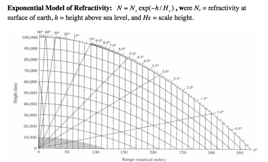
Here is the original document for those interested.
Pressure and water-vapor content decrease rapidly with altitude, while temperature decreases slowly, refractivity and decreases with altitude. Thus, velocity increases with altitude, and rays bend downward. Dominant change in refractivity occurs with along vertical. Key point: not the actual refractivity, but changes (gradient) in refractivity cause rays to bend.
As anyone can see from the above graph, refraction has little impact at both lower heights and the greater the range (which will become important later).
Most curvature experiments performed use an object at a distance that is brought back into focus using an optical zoom. Even if we calculate for curvature error due to refraction (typically 14%), we are left with 86% of the object that is visible without refraction. How can we account for that?
As an approximate compensation for refraction, surveyors measuring longer distances than 300 feet subtract 14% from the calculated curvature error and ensure lines of sight are at least 5 feet from the ground, to reduce random errors created by refraction. (Wiki)
In other words, refraction cannot be used by GE theory to account for objects being visible at a distance that should be below the horizon. So when surveyors are correcting for error, what exactly are they correcting for if they are not on a ball? The predictive model that I created for Polaris could possibly hold the answer. Instead of curvature that is being corrected for, the surveyors are actually correcting for perspective on a flat plane.
I would bet that the error corrections in both radar and other visible light spectrums will be satisfied by the predictive model that was mentioned above. For example, an object at a great height (say 100,000 feet) but at a close range (<1 mile & > 45°) will become obscured at the “top” due to perspective whereas the same object will become obscured at the “bottom” as the range increases and the viewing angle is < 45°.
