I have watched and read FlatEarth (“FE”) content that talks about the issue with flight paths, times and other anomalies that are difficult or impossible on a GlobeEarth (“GE”). However, many GE folks tend to write-off these anomalies by evoking gravity. Though the gravity excuse can be rebuked, it gives the GE folks a free pass. This pass is about to be taken away.
My previous work on curvature calculations has given me the idea to track the flight path of a 747-200 class aircraft during the ascent phase of the journey. On a recent trip to France I recorded the angle of ascent using a bubble level and screen capture software. This allowed me to compare (in real-time) the ascent angle over time with the flight data from Flight Aware. The majority of the ascent was between 1-3°. It lost about 1° of angle every minute. During the initial take off the angle was much higher at around 12° but it quickly reduced to 2° in about 12 minutes. The final 13 minutes was at a nominal angle of 1°. A quick calculation shows that TAN(2°) x 185 miles (6.46 miles) is close to the 6.62 miles achieved after 25 minutes. In other words, the bubble level and the recorded values from flight aware seem to correlate.
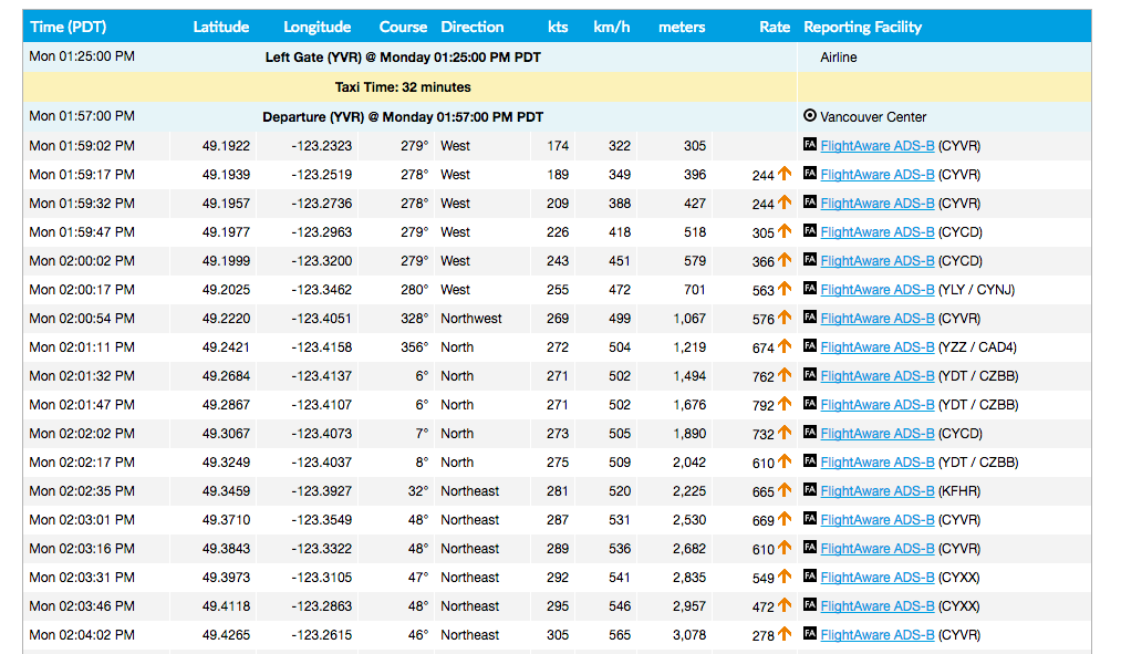
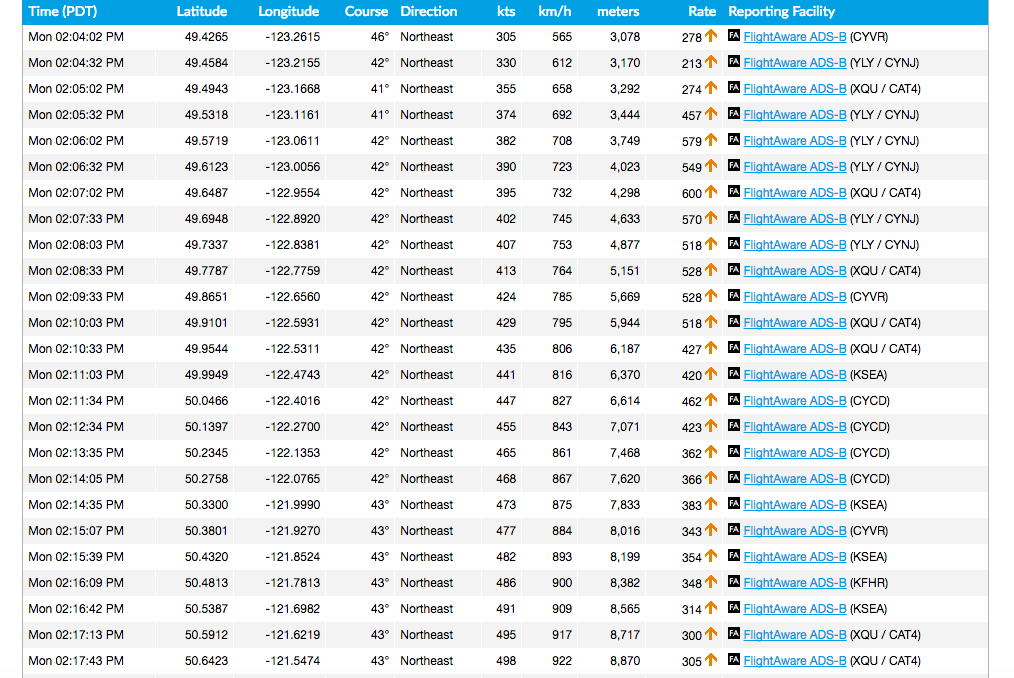
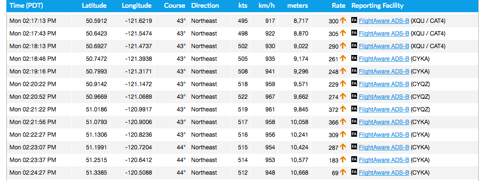
If you have an account at flight aware, you can take a look at the actual flight taken. I will add the data tables here for those who don’t wish to create an account.
The purpose of this post is to show that if there is curvature to the earth, the climb rate over time and the curvature of the earth must place any average international flight at more than double the recorded cruising altitude. This is because the amount of curvature during the ascent phase of the example flight below would be approximately 4.37 miles even without adding any climb at all.
All of the data is publicly available and anyone can do the same calculations I’m going to do. In fact, any international flight can be used for this experiment.
If you take a look at this graph:
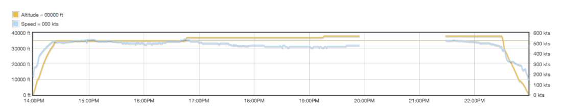
you can see the ascent is in the first 25 minutes and 25 seconds of the flight (01:59:02 – 02:24:27). You can compare this to the table data below:

An examination of this data eliminates a potential objection by GE folks that plane is flying with the curvature of the earth since the plane cannot be tracking with the curvature and ascending at the same time. By it’s very definition, the plane is moving away from the ground (ascending), not tracking with it as it should during cruising altitude. This might seem obvious to most logically minded folks but we are dealing with hardened attitudes that will use any argument, no matter how illogical, to avoid the conclusions reached here.
Since the plane is ascending, and if we are living on a ball, we must take into account the ascending and curvature rates at the same time. There is no getting away from this. This also destroys the idea that gravity keeps the plane moving along the curve, since if this was the case, a plane could never ascend at all. The ascent angle over time is the key.
For example, if a plane took off and ascended at a nominal climbing rate of 1 meter / hour at an average speed of 450 miles / hour, it would reach a cruising altitude of 4.7 miles in 26 minutes. If it continued at this rate for 52 minutes (or an additional 26 minutes), it would be at a cruising altitude of 19.8 miles. The plane can ascend because it’s under it’s own power. It has already overcome the force of gravity or it would fall to the ground. But I digress….
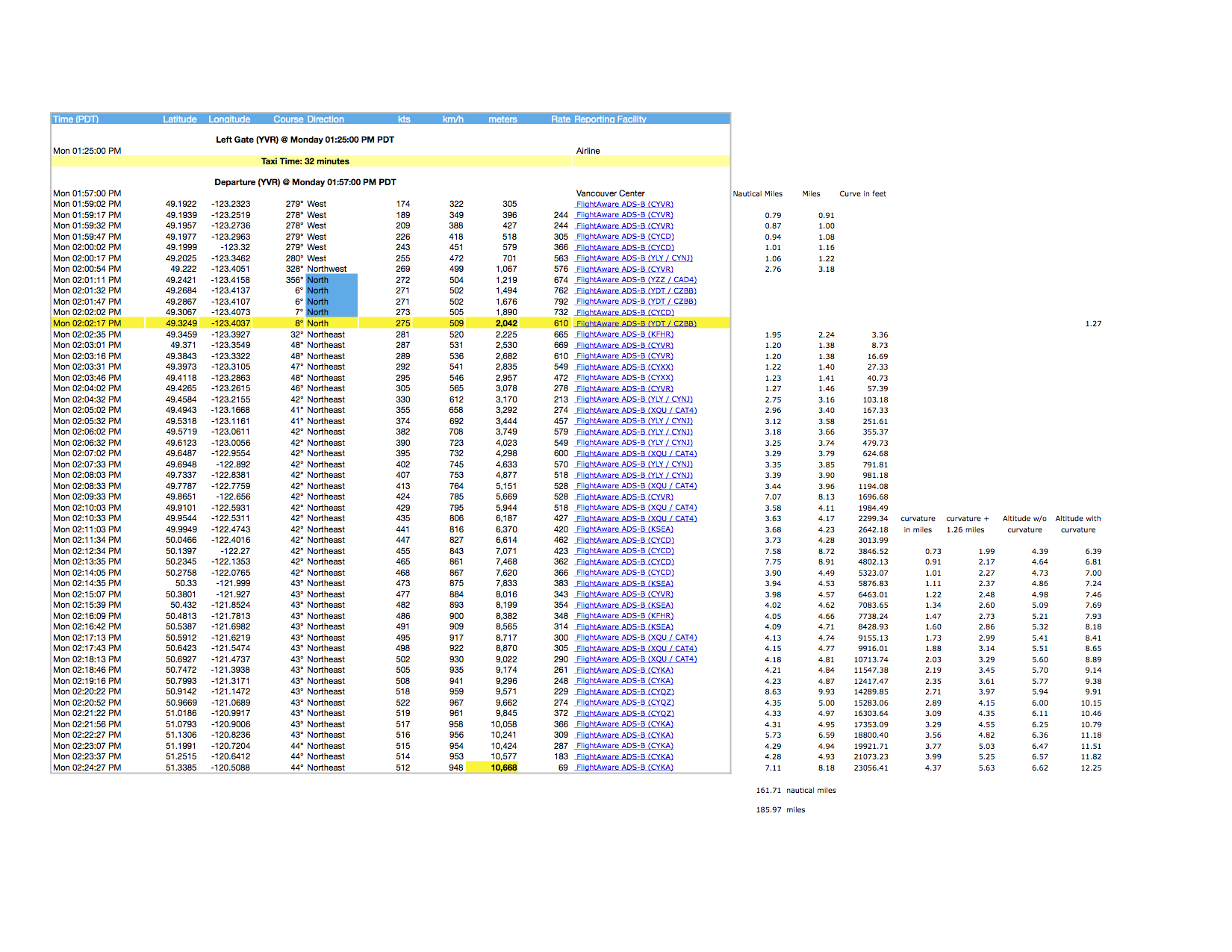
Using a real example, if we include curvature into the calculation with the recorded climb rate, the plane should reach a cruising altitude of 35,000 feet (or 6.62 miles) in approximately 13 minutes. This was calculated using 51 specific data points. Each point contains time, latitude, longitude, course, direction, kts (knots), km/h, meters, climb rate and reporting facility. By calculating the speed by the time interval, I can calculate the total distance travelled during each time interval.
The first 12 data points are ignored for distance travelled since the plane took off in a westerly direction and then turned around to a northeast direction. We still need to include the altitude reach during this time frame which is approximately 1.26 miles. This altitude was reached at 2:02:17 pm.
To accurately calculate the distance travelled, I had to measure the time difference between each data point (between 15-60 seconds) and multiply by the speed of the plane at that interval. This eliminated the use of an average speed which would most likely be used as an additional rebuttal against this proposal.
If you examine the table below, you can see each time interval along with the height and curvature reached.
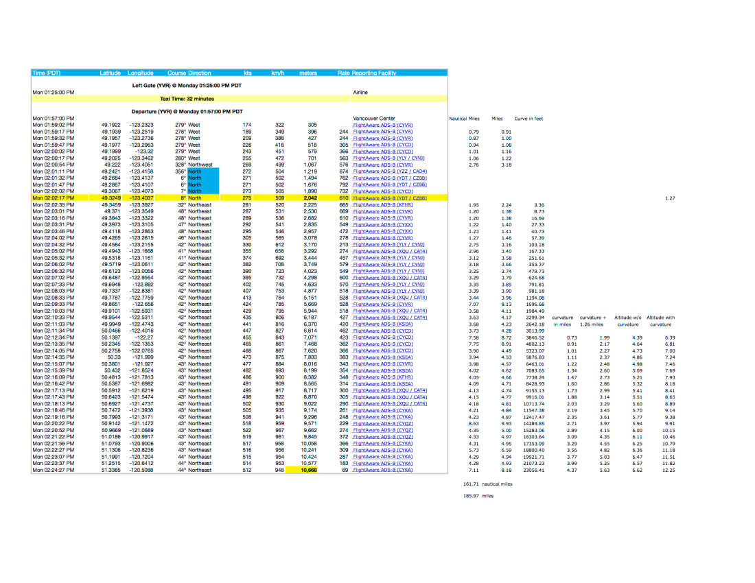
The 7 columns of the far right show the curvature that would occur over the distance travelled. The distance travelled was calculated by converting the speed to nautical miles/min (i.e 281 kts / 60 min = 4.68 nm/min).
I then divided the time frame for each data point by 60 seconds to get the fraction of a minute that the plane travelled during that time frame (ie. 25 seconds / 60 seconds = .41 min)
Once I had that value, I was able to multiply that by the plane’s current speed to get the distance travelled (i.e. 4.68 nm/min × .41 min = 1.95 nm). I then converted the value from nautical miles to miles (i.e. 1.95 nm × 1.15 = 2.24 miles).
Once I had the distance at each interval I could calculate the amount of curvature in feet. Whew !!!
Since curvature is accumulative, the total arc distance from the starting point to the specific time frame must be included not just the distance travelled in that particular time frame.
I finally converted the last 21 data points into miles of curvature. Since the plane was already 1.26 miles in altitude when it started heading northeast, I had to add that value to the curvature accumulated from 02:02:17 pm onward. I calculated both the altitude of the plane without curvature and one with curvature.
As you can see from the table, the cruising altitude should have been reached at approximately the 13 minute mark. Since the plane does not stop ascending at the 13 minute mark but continues for an additional 12 minutes, we are left with the inescapable conclusion that there is no curvature.
I’ve included a link to a post that calculates the distance covered during take off and the time taken to reach cruising altitude for comparison purposes.
https://aviation.stackexchange.com/questions/14357/how-long-after-takeoff-for-a-boeing-747-400-to-reach-cruise-speed